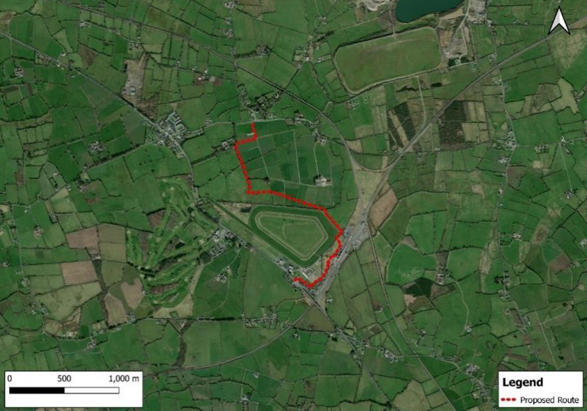
The development will consist of the construction of a walking path from The Soloheadbeg Memorial to Limerick Junction and the N24 at Tipperary Racecourse, over a distance of 2715m. The proposed walking path will be 3m in width and will comprise a base of granular material with a sealed surface of Stone Mastic Asphalt (SMA), with the exception of a 200mm long recycled plastic boardwalk section from Chainage 535 to Chainage 735. Surface water drainage from the path will be catered for in new and existing field drainage ditches and construction of a french drain adjacent to the pathway from Ch1870 to Ch2715.
The proposed development includes ancillary infrastructure comprising of a 1.2m high timber stock-proof fence - where the path adjoins agricultural lands and where the path runs adjacent to water courses, a 2.4m high welded mesh security fence - where the path runs along the boundary of Solohead GAA and Tipperary Racecourse, four fully accessible kissing gates on the walking path at land owner crossing points, field gates to provide land owner access across the pathway, and two pedestrian access gates to provide access to Tipperary Racecourse at the N24.
The proposed development also includes the following:
1. Walkway pedestrian access points at Solohead Gaa entrance on the L4213, and at the N24 adjacent to the existing Tipperary Racecourse car park entrance;
2. installation of walkway entrance advisory signs at the approach to the walkway entrances on the N24 and L4213;
3. installation of a pedestrian bridge crossing the stream at Ch1560;
4. culverting of the existing agricultural drainage ditch from Ch0 to Ch149;
5. installation of culverts at pathway crossing points of existing agricultural drainage ditches at Ch320, Ch550, Ch560;
6. culverts and ground reprofiling at the area liable to flooding near the Tipperary Racecourse at Ch840;
7. culverting of the Dead River from Ch1870 to Ch 1940 and at a pathway crossing point at Ch2400.
The proposed development will be carried out in the townland of Acraboy, Monard, Co Tipperary, the townland Knockaneduff, Donohill, Co. Tipperary and the townland of Ballykisteen, Tipperary, Co. Tipperary.
Stay on display up to and including the 12th July 2024