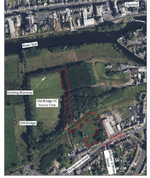
The scheme aims to provide a new active travel connection from the Dungarvan Road (R671) in the Old Bridge area of Clonmel to the Suir Blueway, located approx. 240m north of Dungarvan Road. The project will also include a new car park to the rear of Michael Collins Row, a culvert structure at a minor waterway crossing and a new access from Dungarvan Road opposite William O’Brien Street (L-36712). The scheme will mainly involve the installation of new cycle and pedestrian infrastructure to improve active travel connectivity to the Suir Blueway, as well as improving local amenity in Clonmel, Co. Tipperary.
Location Dungarvan Road (R671) to the Suir Blueway within the townland of Oldbridge, Clonmel, Co. Tipperary.
Nature and Extent of Proposed Development
The proposed project consists of an approx. 345m active travel link between Dungarvan Road and the Suir Blueway. The Blueway Link runs from the Dungarvan Road / William O Brien Street junction in a northly direction for approx. 100m before connecting to the top of the existing flood defence embankment. The route then travels in a south-westerly direction along the top of the embankment for approx. 70m before turning in a northly direction again for approx. 175m to meet the existing Suir Blueway.
The maximum proposed grades on the Blueway Link will be 5%. The existing footpath on the northern side of Dungarvan Road will be reconstructed and widened along a length of approx. 75m to provide safe access to the Blueway link for cyclists and pedestrians. Where the existing vehicle access route to Old Bridge soccer club interacts with the proposed Blueway link, new pedestrian and vehicular gates will be provided. Ball stop netting will be provided behind the existing goal posts on the eastern end of the soccer pitch.
The proposed project consists of a 3.0m wide shared use path with 0.5-1.0m grass verges between Dungarvan Road and the Suir Blueway. Grass verges of 1.0m are provided for the majority of the project except where space is constricted on top of the embankment where verges will reduce to 0.5m along this section. New car parking facilities with 12 parking spaces will be provided at the rear of Michael Collins Row to service the Blueway Link. The proposed car park entrance will be located on Dungarvan Road opposite William O'Brien Street.
Removal of a tree and some existing vegetation is required at the car park entrance. An existing outhouse including approx. 14m of wall, adjacent to an existing unoccupied house, is to be demolished to provide access to the car park. The unoccupied house will remain in place. A controlled pedestrian crossing facility will be provided on Dungarvan Road to the east of the proposed Blueway Link.
A new culvert crossing of the existing watercourse along the north side of the existing flood defence embankment will be provided under the Blueway Link.
The proposed Blueway Link will have an asphalt surface finish and the reconstructed footpath will have a concrete surface finish. Proposed drainage will generally consist of over the edge drainage along the Blueway Link route, relocated gullies connecting to existing drainage pipes along Dungarvan Road and new drainage pipes at the new car parking facilities.
Existing traffic signs, public lighting columns, utilities and drainage manholes may need to be relocated or removed as part of the works and new public lighting columns will be provided along the full length of the proposed Blueway Link.
Timber stud fencing will be provided along the majority of the Blueway Link route and around the proposed car park with metal mesh fencing provided within the soccer club at both sides of the ball stop netting.
The development has been the subject of an Appropriate Assessment screening in accordance with Article 6(3) of the EU Habitats Directive (Directive 92/43/EEC) and article 250(1) of the Planning and Development Regulations 2001 as amended. The Appropriate Assessment screening concluded that the proposed development would not be likely to give rise to significant or indeterminate impacts on any Natura 2000 site.
Having regard to the information specified under Schedule 7A of the Planning and Development Regulations 2001, as amended, and based on an examination of the nature, size and location of the development, it is determined that there is no real likelihood of significant effects on the environment arising from the proposed development and an Environmental Impact Assessment is not required.
Plans and particulars of the proposed development, including Appropriate Assessment Screening and Environmental Impact Assessment Preliminary
Examination report will be available for inspection or purchase at a fee not exceeding the reasonable cost of making a copy at: -
- Tipperary County Council, Civic Offices, Emmet Street , Clonmel, Co. Tipperary, E91D5T7
- Tipperary County Council, Civic Offices, Limerick Road, Nenagh, Co. Tipperary, E45 A099
from 09:30am- 4:30 pm Monday to Friday for a period 06th of August 2025 to 04th of September 2025 (excluding public holidays).
Details of the proposed development are also available online at https://planning.localgov.ie/
Submissions or observations with respect to the proposed development, dealing with the proper planning and sustainable development of the area in which the development will be situated, may be made in writing and addressed to Mr. David Carroll, Acting Director of Services Planning and Development, Emergency Services and Emergency Planning, Tipperary/Cahir/Cashel Municipal District, Tipperary County Council, Civic Offices, Nenagh, Co Tipperary, correspondence should be clearly marked ‘Part 8 in respect of Old Bridge to Suir Blueway Link ‘ no later than 4.30pm on Friday 19th September 2025.
Any person may, within 4 weeks from the date of this notice, apply to An Coimisiún Pleanála for a screening determination as to whether this development would be likely to have significant effects on the environment.