A new project website has been developed to bring together all of the Suir Island Infrastructure Links Project information including planning documentation and referenced documents and can be found here:”
https://www.tipperarycoco.ie/suirislandinfrastructure
TAKE NOTICE that Tipperary County Council, having published Notice on 28th September 2023, has decided to publish further Notice which includes additional particulars of the proposed road development and has extended the period for inspection and the making of submissions or observations until Monday 18th December 2023 as follows:
TAKE NOTICE that Tipperary County Council has applied under Section 51(2) of the Roads Act 1993 (as amended) to An Bord Pleanála (‘the Board’) for approval in relation to a proposed road development consisting of the construction of:
- Two pedestrian bridges, the first bridge linking the proposed North Plaza on The Quay/Quay St/Sarsfield St Junction to Suir Island, and the second bridge connecting Suir Island to Raheen Road.
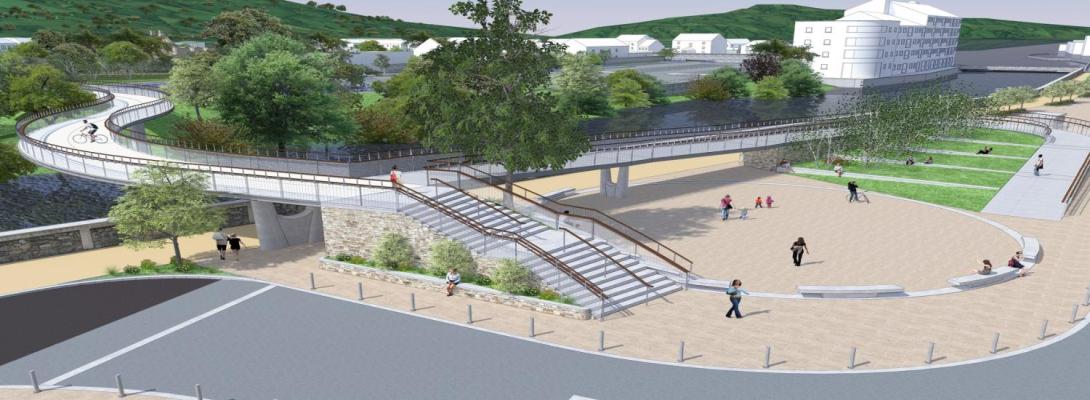
- The pedestrian bridges will be 4-metre-wide consisting of a double curvature alignment, which allow users to discover Suir Island ‘from up high’ by walking seamlessly between the trees while linking the project elements (North Plaza, the berm embankment, and the south riverbank) along one sinuous route. The first bridge follows the geometry of Sarsfield Street and arrives on the island following the line of the berm embankment, which then links onto the second bridge facilitating a link to Denis Burke Park on Raheen Road, creating a direct connection for pedestrians/cyclists between the park and the Town Centre.
- Provision of a new public open space called the North Plaza which will be aligned with Sarsfield Street. The steps and ramp will be visible from O'Connell Street creating a new landmark in the town of Clonmel and will encourage pedestrian movement towards the River Suir. The bicycle access ramp is designed to be as transparent as possible so as not to block the view of Suir Island from Sarsfield Street.
- Modification of traffic direction and carriageway widths in The Quay and Quay Street around the proposed North Plaza.
- Provision of a bus stop on the western side of the North Plaza located on Quay Street with five benches providing comfortable facilities for public transport users.
- Upgrading of the existing 2-metre-wide sidewalk along Quay Street into a 4-metre-wide shared pedestrian/cycle path which will provide unencumbered access to the proposed plaza area underneath the elevated access ramp.
- Provision of a sloping landscaped terrace with public seating, located inside the hairpin-shaped access ramp leading up to the northern bridge crossing.
- Provision of three benches and a 9-metre-long stepped promenade seating area integrated into the circular-shaped plaza.
- Planting of various native tree species around the North Plaza to integrate the proposed development with the existing scenery of Suir Island and complement the visual experience of users.
- Provision of a pedestrian path or promenade along the existing berm embankment across Suir Island linking the two pedestrian bridges, to facilitate access between Denis Burke Park on Raheen Road and the proposed North Plaza on The Quay.
- Construction of a pedestrian/bicycle ramp from the link promenade onto Suir Island Carpark. The ramp is fully integrated into the landscape by using the existing slope of the berm.
- Construction of three sets of steps connecting the link promenade to Suir Island carpark and the eastern end of Suir Island.
- Provision of a mini public space within Suir Island Carpark at the entrance to the proposed Suir Island Gardens.
- Provision of a south arrival point for the second bridge connecting Suir Island to the Raheen Road. The South Arrival Point will consist of one access ramp to the east and one set of steps to the west, integrated with the bridge landing level and running parallel to the footpath. These elements will be located outside the existing flood barrier.
- Road improvements for the safety of pedestrians/cyclists at the South Arrival Point, including the footpaths being widened and the road narrowed to accommodate 3.0-metre-wide lanes. Removal of three carparking spaces from the southern edge of the road to allow for wider footpaths.
- Installation of two uncontrolled pedestrian crossings positioned at either ends of the proposed access ramp and flight of steps to provide traffic calming at the South Arrival Point. This bridge arrival point will be located close to the school entrance of Raheen College, providing safe and convenient access for the schoolchildren.
- Access ramps and steps are located behind the flood barriers to allow access even during flood events.
- Construction of a new foul pumping station to be located within Suir Island car park which will facilitate future Irish Water connections. Wastewater will be pumped 0.1km approx. via rising main along the proposed bridge linking Suir Island to the proposed North Plaza where it will connect into the existing public network along The Quay.
- Ancillary site development works to include, but not limited to, surface water drainage, lighting and associated electrical works, hard and soft landscaping, road works to include surfacing and line marking, landscaping and installation of street furniture.
- All associated, ancillary and consequential site works.
The proposed development is located at The Quay, Quay Street, Suir Island and Raheen Road in Clonmel County Tipperary.
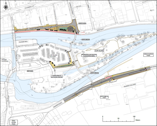
The location of the proposed development is illustrated in the map below.

An Environmental Impact Assessment Report has been prepared in respect of the proposed development.
The proposed development has the potential to impact on a designated European site or sites. A Natura Impact Statement has also been prepared and submitted in respect of the proposed development under Part XAB of the Planning and Development Act, 2000, as amended, for the purposes of Article 6 of the Habitats Directive.
The application documentation including the Environmental Impact Assessment Report and the Natura Impact Statement may be inspected free of charge or purchased at a fee not exceeding the reasonable cost of making a copy, at the following locations on working days between the hours of 9.30am and 4.30pm between Friday 29th September 2023 to Monday 18th December 2023 inclusive (excluding public holidays) :
At
- Tipperary County Council, County Offices, Emmet Street, Clonmel, County Tipperary E91D5T7
- Tipperary County Council, Civic Offices, Limerick Road, Nenagh, County Tipperary, E45A099
And the offices of An Bord Pleanála, 64 Marlborough St, Dublin 1, D01 V902. Opening hours: Monday to Friday – 9.15am to 5.30 pm (Tel: 01 8588100)
The Board may, in relation to an application for approval under Section 51 of the Roads Act 1993 (as amended), by order, approve the proposed road development with or without modifications or it may refuse such development or any part thereof.
Submissions or observations may be made, in writing, to the Board at An Bord Pleanála, 64 Marlborough St, Dublin 1, D01 V902 and must be received during the period specified above i.e., on or before 5.30pm on Monday 18th December 2023 in relation to:
- the implications of the proposed development for proper planning and sustainable development of the area in which the development is concerned;
- the likely effects on the environment of the proposed development, and
- the likely significant effects of the proposed development on a European site, if carried out.
Any submissions/observations must be accompanied by a fee of €50 and must be received by the Board not later than 5.30pm on 18th December 2023. This fee will not apply to certain prescribed bodies including those specified in Section 51(3)(b) of the Roads Act 1993 (as amended) or to landowners.
Submissions/observations can also be made on the An Bord Pleanála website at the following address: https://online.pleanala.ie/en-ie/sid/observation.
Any enquiries relating to the application process should be directed to the Strategic Infrastructure Development Section of An Bord Pleanála (Tel. 01-858 8100)
A person may question the validity of any decision by An Bord Pleanála on a proposed road development by way of an application for judicial review, under the Rules of the Superior Courts (and in particular Order 84 of the Rules of the Superior Courts contained in S.I. No. 15 of 1986 as amended) and in accordance with Sections 50, 50A and 50B of the Planning and Development Act 2000 (as amended).
Practical information on the review mechanism can be accessed under the heading: “Legal Notices – Judicial Review Notice” on An Bord Pleanála website www.pleanala.ie. This information is also available on the Citizens Information Service website www.citizeninformation.ie.
Dated this 16th day of October 2023.
Signed:
Marcus O’Connor, Director of Services
Roads, Transportation and Infrastructure, Tipperary County Council,
Civic Offices, Limerick Road, Nenagh, Co. Tipperary.


